on september 17, the journal global change biology published a review paper fromma xuanlong'steam at our school of earth and environmental sciences “monitoring nature’s calendar from space: emerging topics in land surface phenology and associated opportunities for science applications”. the review system to review the latest research progress of the epicontinental phenology, including the global change ecology, terrestrial carbon cycle, some key scientific problems of urbanization and human health, as well as new satellite sensors, geographical network data, and emerging technologies. they discuss the areas that need to be paid attention to in the next stage of land surface phenology and propose that the development of remote sensing phenological parameter inversion technology should be closely coupled with the scientific issues concerned by ecology, agronomy, and global change.
phenology mainly studies the seasonality of plant and animal growth and its relationship with environmental factors. in the context of climate change, phenology, as the most direct way to reflect the response of ecosystems to environmental change, has attracted more and more academic attention. the accurate expression of vegetation phenology can significantly improve the simulation accuracy of carbon, water, and energy cycles in global terrestrial ecosystems. as a cross-discipline of remote sensing, ecology, and biometrics, terrestrial phenology studies how to use satellite remote sensing technology to monitor the seasonal dynamics and phenological phases of terrestrial vegetation on a global scale. with the improvement of satellite sensor performance and the continuous innovation of data fusion technology, it is possible to refine phenological changes at a higher spatial and temporal resolution, which provides a new opportunity to study the fine-scale dynamics of ecosystems. however, there has been a lack of systematic, scientific problem-focused reviews on the development of continental phenology. to this end, ma xuanlong'steam collaborated with scholars from the united states, switzerland, australia, and singapore to conceive and complete the review based on several online and offline discussions (ma et al. 2022).
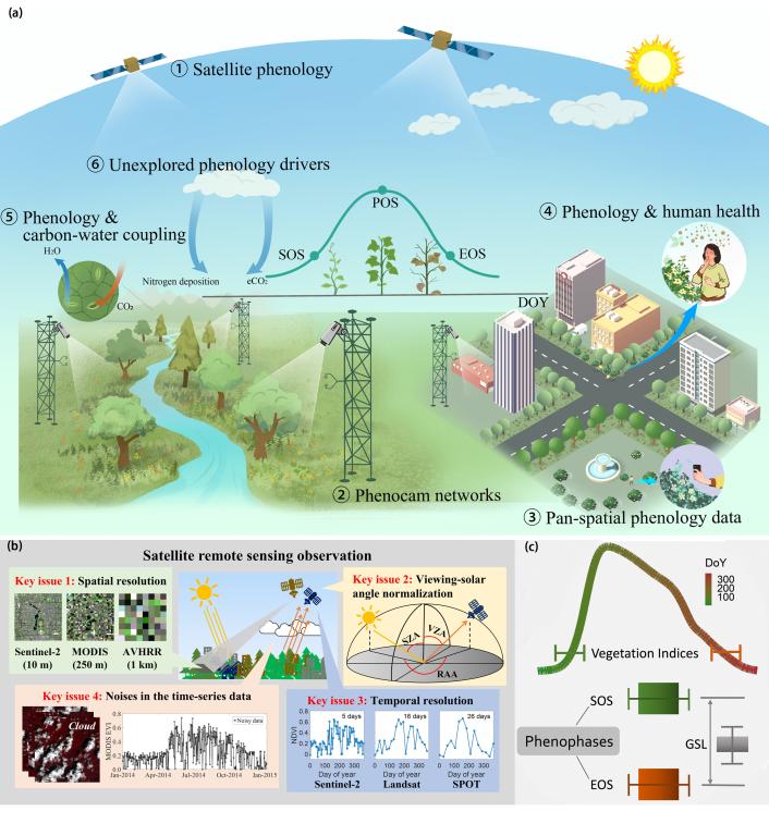
fig 1. (a) six emerging important themes in continental phenology; (b) technical challenges of satellite remote sensing phenological parameter inversion; (c) schematic diagram of key epicontinental phenological periods (ma et al. 2022).
in the past two years, ma xuan long's research team has made a series of progress in the basic research of quantitative vegetation remote sensing and the application of ecological monitoring. the sensors carried by the new generation of geostationary orbit satellites have a higher spatial, temporal and spectral resolution, which provides a new opportunity for ecological remote sensing monitoring applications. for example, china's fengyun 4-a satellite and japan's sunflower 8 (h8/ahi) satellite are equipped with sensors that can obtain atmospheric and ground observation data in the spectral range of visible light, near-infrared and thermal infrared at an observation frequency of 10 minutes. how to use the unprecedented mass of geostationary satellite observations to form high spatio-temporal consistency and high precision vegetation parameter datasets for the scientific research of global change and ecological remote sensing is an urgent challenge in the field of quantitative vegetation remote sensing. therefore, based on the high-frequency geostationary satellite observations, the research team developed a set of effective geostationary satellite data preprocessing and vegetation parameter daily synthesis algorithms considering cloud masking and brdf effect and explored the seasonal vegetation dynamics and phenological changes in different ecosystems on this basis. the results show that, due to the higher temporal resolution, the geostationary satellite observation can better overcome the cloud masking and brdf effect, improve the data integrity and accuracy of vegetation dynamic remote sensing, and help us understand the response mechanism of global vegetation to climate change on a more detailed temporal scale. the relevant results were published in the international journal of applied earth observation and geoinformation (impact factor 7.672) (zhao et al. 2022).
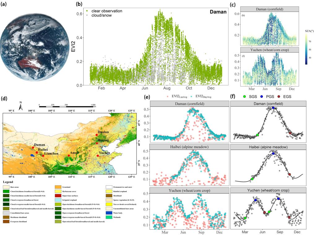
fig 2. (a) himawari-8 full-disk image; (b) cloud and cloudless observations of h8/ahi at the daman site within one year; (c) variation of solar zenith angle corresponding to h8/ahi annual observations in daman, gansu province and yucheng, shandong province; (d) distribution of study sites; (e) comparison of h8/ahi synthesis methods on different days; (f) extraction effect of key phenological parameters from daily h8/ahi synthetic data at site scale (zhao et al. 2022).
regional and global scales of satellite remote sensing observation are accompanied by space and time on the solar zenith angle (sza) great changes, but the sun angle change on the effect of dynamic remote sensing of vegetation is still largely unknown, how to quantify and correction effect of sun angle is a basic scientific problem in the field of quantitative remote sensing of vegetation. to address this scientific problem, the research team developed a quantification method that combines integrated satellite observations with brdf model simulations. combined with polar-orbiting satellite and geostationary satellite observations, the influence of seasonal solar zenith angle variation on vegetation index time series was simulated and analyzed, and the uncertainty caused by the extraction of vegetation phenological parameters was quantified. the results showed that the sensitivity of ndvi and evi to the change of solar angle was significantly different in different vegetation types and different growing season stages, and the sensitivity of ndvi was much higher than that of evi. at the same time, due to the change of vegetation composition and structure in pixels caused by the growth of vegetation in the season, the response mode of vegetation index to the change of solar angle in different seasons is quite different. the relevant results were published in remote sensing (impact factor: 5.349), an authoritative journal in the field of remote sensing (ma et al. 2020).
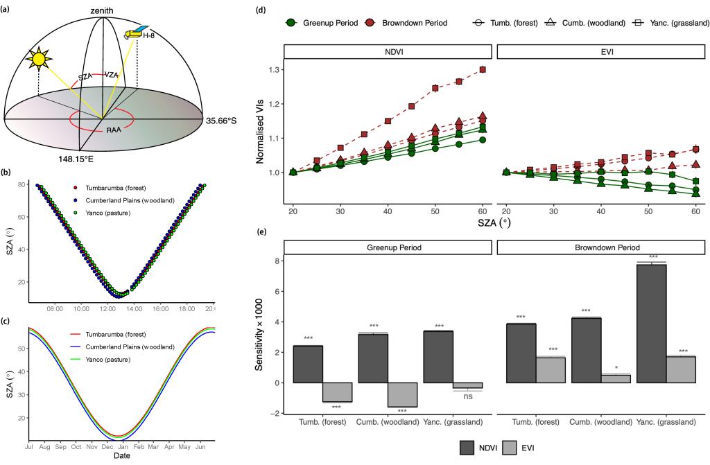
fig 3. (a) geometric diagram of h8/ahi solar observation at site location; (b) h8/ahi solar angle diurnal variation maps at different sites; (c) annual variation of the zenith angle of the h8/ahi at local noon time at the site; sensitivity analysis of (d, e) vegetation index (vis) to changes in solar zenith angle (sza). (d) is the response of ndvi and evi to sza in the range of 20-60°; (e) is the sensitivity analysis of ndvi and evi to sza changes in different vegetation growth stages. vis is normalized to visza20 for comparison between sites. sensitivity refers to the change value of vis with sza per degree. the error lines on the figure represent 95% confidence intervals for the mean, and the statistical significance of the slopes is indicated as follows: *** (p < 0.0001), * (p < 0.01), ns (not significant, p > 0.05) (ma et al. 2020).
at present, international research on global change and ecological remote sensing is still dominated by european and american satellite data. the domestic satellite data has some pressing problems, such as low calibration accuracy, imperfect product development, and low application level in related fields. to get rid of the key scientific issues and areas of the significant national economy to rely heavily on foreign satellite remote sensing data, the research team, from the perspective of the basic research, aiming at the challenges facing the domestic satellite application process, the development of innovative data processing procedure and parameters inversion algorithm, to promote domestic research level in the field of ecological environment of remote sensing satellite. in cooperation with scholars from the national meteorological satellite center, the land satellite remote sensing application center of the ministry of natural resources, and the state key laboratory of remote sensing science, the team systematically reviewed the research progress of a series of domestic satellites including fengyun, resources, environment, and gaofen in the field of vegetation ecological remote sensing in recent years. by comparing the performance parameters and application levels of the current international mainstream earth observation satellite sensors, the advantages and disadvantages of domestic satellites are clarified, which provides a scientific and beneficial reference for the next development of domestic satellites and the improvement of the depth and breadth of applications (zhang et al. 2022).

fig 4. (a) comparison of the band settings of the new generation of domestic earth observation satellites and the similarly designed international satellites; (b) distribution of launch and service times of domestic satellites; (c) ndvi distribution in the vegetation growing season over northwest china and central asia in 2020 based on domestic fengyun satellite (zhang et al. 2022).
ecological protection and high-quality development of the yellow river basin is a major national strategy. located in the upper reaches of the yellow river and the southeastern edge of the qinghai-tibet plateau, gannan is one of the most important water conservation areas of the yellow river. in order to better fulfill the responsibility of our university in serving the major national strategy and local economic development, the research team studied the vegetation cover changes and driving factors of the important water conservation areas in the upper reaches of the yellow river in gannan in the past two decades based on high-resolution and long-term remote sensing satellite data. it is found that vegetation is more sensitive to changes in temperature than to changes in precipitation in humid and sub-humid areas, while this pattern is reversed in semi-arid areas. under the same climate background conditions, different vegetation types have great differences in climate change sensitivity. the results of the study on the spatial scales reveal the headwaters of the yellow river basin of vegetation to climate change in response to the sensitivity of the differences and the deep cause of the difference, for a more accurate prediction of the upstream headwater of the yellow river ecological system under the future climate change trend of the development of and formulate a scientific and reasonable regional sustainable development and ecological protection policy provides the theoretical basis, the relevant results were published in remote sensing, a leading journal in the field of remote sensing (liang et al. 2022).
fig 5. (a) the position of gannan water conservation area in qinghai-tibet plateau and yellow river basin; (b) spatial distribution of vegetation cover (fvc) change trend in gannan water conservation area from 2000 to 2020; (c) distribution of correlation coefficients between fvc and precipitation or temperature on different dryness indices in gannan water conservation area; (d) fvc slope distribution of main vegetation types on different dryness indices in gannan water conservation area from 2000 to 2020 (liang et al. 2022).
the ma xuanlong research team of the school of earth and environmental sciences of our university is mainly engaged in the research of ecological remote sensing and global change, developing the theory and method of macroscale ecosystem change monitoring based on remote sensing and geographic information technology, and quantifying the response of ecosystems to climate change and human disturbance. in recent years, the team has made a number of breakthroughs in key ecological remote sensing technologies such as vegetation phenology parameter extraction, vegetation productivity, and biodiversity estimation. based on these breakthroughs, the team has explored and discovered important natural phenomena and laws of environmental changes in typical ecologically vulnerable areas. the team was invited to participate in the 2021 earth big data for sustainable development goals monitoring and evaluation results exhibition, the relevant results are included in the "earth big data for sustainable development goals report (2021)". team leader ma xuan long was invited to attend the 2021 annual meeting of the asian-oceanian geoscience society and the 2022 international forum on big data for sustainable development and delivered a special presentation. in 2021, he was awarded the kamide lecture award (young research award) by the asian-oceanian geoscience society.
the above work is supported by the national natural science foundation of china (42171305), the natural science foundation of gansu province (21jr7ra499), the basic research fund of the central universities (lzu-jbky-ct11), the open project of the state key laboratory of remote sensing science (ofslrss202229), and the state key of resources and environmental information system supported by the open laboratory project, the open key laboratory of geographic information science of the ministry of education (klgis2022a02) and the director's fund of the international research center for big data for sustainable development (cbas2022df006).
related papers and links:
ma, x.*, zhu, x., xie, q., jin, j., zhou, y., luo, y., liu, y., tian, j., zhao, y. (2022). monitoring nature’s calendar from space: emerging topics in land surface phenology and associated opportunities for science applications. global change biology, doi:10.1111/gcb.16436.
zhao, y., wang, m., zhao, t., luo, y., li, y., yan, k., lu, l., tran, n.n., wu, x., ma, x.*(2022). evaluating the potential of h8/ahi geostationary observations for monitoring vegetation phenology over different ecosystem types in northern china. international journal of applied earth observation and geoinformation, 112, 102933.
liang, y., zhang, z., lu, l., cui, x., qian, j., zou, s., ma, x.*(2022). trend in satellite-observed vegetation cover and its drivers in the gannan plateau, upper reaches of the yellow river, from 2000 to 2020. remote sensing, 14(16), 3849.
zhang, z., lu, l., zhao, y., wang, y., wei, d., wu, x., ma, x.*(2022). recent advances in using chinese earth observation satellites for remote sensing of vegetation. essoar, doi: 10.1002/essoar.10510984.1.
wang minyu, luo yi, zhang zhengyang, xie qiaoyun, wu xiaodan, ma xuanlong *. (2022). research progress on remote sensing extraction and validation of vegetation phenological parameters. journal of remote sensing, 26(3): 431-455. doi: 10.11834/jrs.20211601.
ma, x.*, huete, a., tran, n.n., bi, j., gao, s., zeng, y. (2020). sun-angle effects on remote sensing phenology observed and modeled using himawari-8. remote sensing, 12(8), 1339.
research results of lanzhou university were selected in the "earth big data for sustainable development goals monitoring and evaluation" exhibition.
ma xuanlong invited to asia, oceania society for earth science and titled "empowering ecological monitoring the from space" special report