how each climate element changed during the sustained warm phase of climate in the geological historical period is instructive for understanding future climate change in the context of global warming. the continuous quaternary loess deposits on the loess plateau are a good vehicle for studying monsoonal changes in east asia, placing china at the forefront of paleomonsoon research in the world. however, how to extract reliable orbital-scale monsoon change information from the overlying red clay sediments has been the focus of debate among geologists at home and abroad. this is mainly due to the lower deposition rate and stronger oxidation of red clay. the magnetization rate of quaternary loess is mainly determined by the content of fine-grained subferromagnetic minerals generated by soil-forming action, and these subferromagnetic particles are very magnetic although their contents are small in general, and even the presence of a small amount can play a decisive role in the magnetization rate. therefore, the magnetization rate of chinese loess can reflect the strength of soil formation and thus indicate the strength of monsoon precipitation in east asia. however, the red clay was deposited in the warmer late miocene-pliocene period, and the soil-forming process is significantly different from the quaternary period, and the magnetic minerals may be more transformed into hematite. therefore, considering only the magnetization rate dominated by subferrous magnetic minerals would not provide a full picture of the variation in the strength of monsoonal precipitation. a full understanding of the monsoon precipitation information recorded by magnetic minerals requires consideration of both the relative content variations of subferrous magnetic minerals and hematite. it has been shown that the ratio of ferrous magnetic mineral content to hematite content (estimated by χfd/hirm) in the fine particles of modern soils is an accurate indicator of the variability of monsoon precipitation. however, this indicator has not been applied to red clay sequences.
the late miocene pliocene, the closest period of sustained climate warmth, is considered a similar period for future climate, and international working groups have been established specifically to study climate change during this period. however, there are different perceptions of how the east asian summer winds changed during this period. in this context, nie junsheng's team at lanzhou university and co-workers applied the indicator to the middle pliocene warm period in red clay for the first time (fig. 1), generating a millennial-resolution monsoon precipitation record. the monsoon precipitation was found to have a very significant 20,000-year age difference cycle during this warm period (fig. 2(a) and (b)) and was consistent with the local summer solar radiation variation, which is consistent with the climate simulation results.

figure 1. the red clay strata in chaona profile
this ratio indicator reveals a significant age difference cycle of east asian monsoon precipitation and a clear inclination cycle (fig. 2(c)). however, unlike the 20,000-year cycle, the east asian monsoon precipitation is less when the loess plateau region receives more solar radiation in summer (fig. 2(c)). this indicates that the driving mechanism of east asian monsoon precipitation at the 40,000-year scale differs from that at the 20,000-year scale. considering that ice cap size may be another important factor controlling the asian monsoon in addition to solar radiation, the team compared the variation of the χfd/hirm index record on the 40,000-year scale with the deep-sea oxygen isotope record and found that the loess plateau precipitates more when the ice cap is larger (fig. 3(a) and (b)), which is consistent with some simulations predict. therefore, the team attributes the 40,000-year-scale changes in precipitation on the loess plateau to be driven by the ice cover. however, the ice magnitude may be driven by global co2content, which also suggests that co2content may also be a factor in the 40,000-year-scale loess plateau precipitation variability.
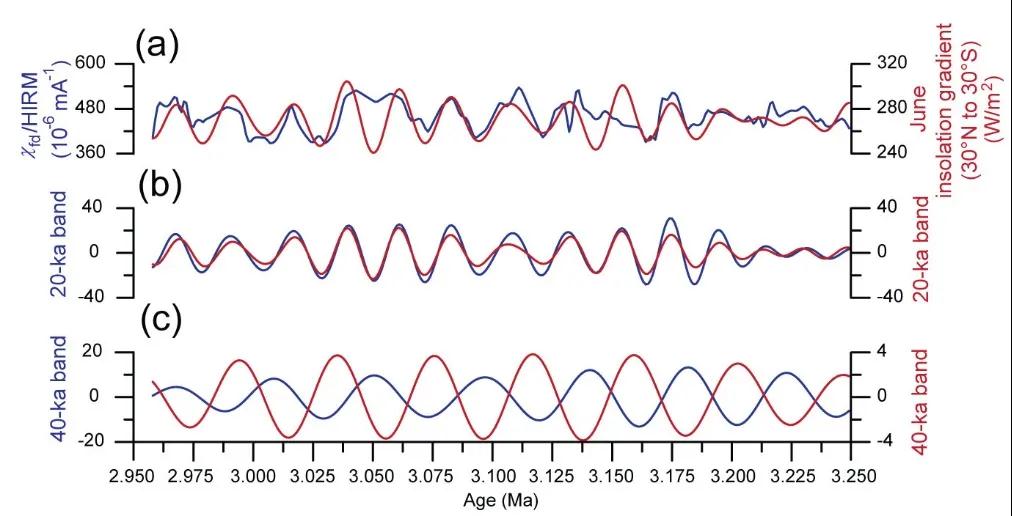
figure 2. comparison of monsoon precipitation index records and solar radiation in chaona profile: (a) comparison of the χfd/hirm indicator record with the solar radiation gradient in june; (b) comparison of the 20,000-year cycle signals of the two records in a; (c) comparison of the 40,000-year cycle signals of the two records in a
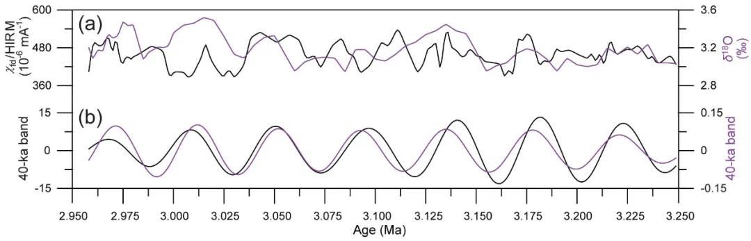
figure 3. monsoon precipitation index record of chaona profile compared with global ice volume: (a) comparison of the χfd/hirm index record with the deep-sea δ18o curve; (b) comparison of the 40,000-year cycle signals of the two records in a.
science bulletin, vol. 4, no. 2021 reported on the study with the title.the first author of the paper is luo zeng, a phd student at lanzhou university, and the corresponding author is prof. nie junsheng. the co-authors are from california state university, brown university, rochester institute of technology, northumbria university, newcastle, uk, and jiangsu normal university. this study reveals that precipitation in the loess plateau region had significant age and dip cycles during the most recent period of sustained warmth (about 3 million years ago), which preliminarily resolves the inconsistency between the geological record and simulations of east asian monsoon precipitation at the orbital scale during the pliocene warm period, and also provides reference geological evidence for understanding future changes in east asian monsoon precipitation. this study was co-funded by the second integrated scientific expedition to the tibetan plateau (2019qzkk0704) and the national natural science foundation of china (42030505 and 41672157).